
Orthomosaics
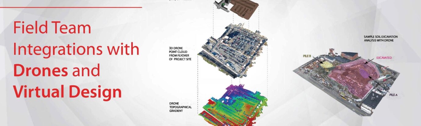
Orthomosaics are a frequently requested deliverable produced by drones. An orthomosaic is a large-scale, top-down high-quality photo created by stitching together hundreds of individual photos taken by the drone. Drones can be programmed to fly missions that generate orthomosaics, to ensure that a consistent image can be produced flight after flight. The result is a super high-quality image covering the exact area of the project site. This allows project teams to utilize updated site conditions images for items like logistic planning, safety maps, sequence referencing, installation tracking and more.
Point Clouds
Point clouds can be considered a large matrix of data points in space created by 3D scanners. Gilbane’s Virtual Design and Construction (VDC) already uses laser scanners to create highly accurate and detailed point clouds, but advanced drones can also produce point clouds, albeit less-detailed, simply by using their cameras. Known as Drone Point Clouds, these can provide a huge benefit to project teams when calculating cut and fill needed on site. Post-flight drone images can be stitched together to generate a 3D Drone Point Cloud. This gives our team rough estimates of geometries on site, which allows for measurements to calculate volume of piles or cut/fill data. Although not perfect, this quick check of 3D data can be significantly less expensive than a traditional take-off or survey. With more accurate estimate of material amounts, detailed numbers can be calculated to determine the number of trucks needed for offloading, improved estimates of materials needed, and more. The Drone Point Cloud can also be used to measure elevations, distances, and areas to help project teams get better estimates and in a drastically reduced time than without the use of drones.
Success Stories
On one specific job in Boston, the operations team has leveraged the monthly drone orthomosaics to create site logistic and safety plans that are then shown on a screen daily for teams in the trailer to utilize. They also have printouts laminated for anyone wanting to see the most up to date construction progress. This is helpful not only for the Gilbane project team but also for the trades and owners. Images can be marked up so that everyone can get a clear understanding of what is happening on site; a truly different way to view and analyze the ever-changing site conditions. Imagine an overall perspective of all anchor bolt locations before any concrete is poured!
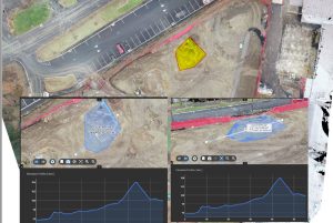
Our Connecticut team has also been presented with unique scenarios where drone services brought enhanced value to the project. A project manager needed a way to quantify the cubic yardage of soil removal to present to the owner. The drone pilots were able to come in on a moment’s notice, fly, capture the soil conditions overhead, and extract a Drone Point Cloud to estimate the volumes. In turn, the project manager was able to quickly provide a rough order-of-magnitude to the architect and owner so they could better understand what was happening on site.
New Challenges … and Beyond?
Gilbane projects across the country currently have the capabilities to provide multiple levels of drone deliverables – with help from local VDC teams and Gilbane drone pilots scattered across the nation. Drone technology is growing rapidly, and Gilbane is continually finding innovation applications to the construction industry through use of self-flying drones, orthomosaics, and 3D Drone Point Clouds. Envision combining the drone deliverables with the innovative services that VDC creates daily; what other new ways could we have been analyzing our sites?